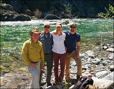
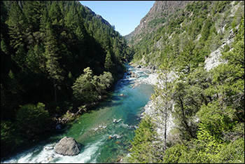
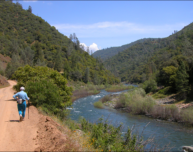
1) Green Valley Hike on May 21
Join NFARA for a hike onSaturday May 21 down to Green Valley. This;all day hike will start at 8:30 AM from the Euchre Bar Trailhead at Iron Point. The hike will follow the Euchre Bar Trail a bit to the junction of a trail that heads to Green Valley. Green Valley, just up canyon from Giant Gap, is an unusually wide part of the North Fork Canyon. It was one of the old mining camps that reportedly had a population nearly 2,000 at its peak. Many old ditches, obscure trails, and mining sites are here as well as magnificent views of Giant Gap and Lovers Leap.
While the hiking in Green Valley is very moderate, the trail in and out is steep and should be considered strenuous. The trail drops 1,870 feet in two miles and of course you have to climb back up. You need to be in good shape with good sturdy hiking boots. Bring plenty of water and a lunch to eat at the river.There is poison oak.The leader reserves the right to reject any participant not prepared. If interested, please contact Catherine O'Riley at canyonspirit@yahoo.com.
Directions to the trail head:
Take the Alta exit on I-80. If coming from the west, turn right at the end of the exit, then immediately left at the stop sign onto Casa Loma Rd. If coming from the east, turn left at the end of the exit, then go under I-80 to the stop sign and turn left onto Casa Loma Rd. In 0.9 miles take the right fork, then the railroad is crossed at 1.3 miles and at 2.7 miles the road comes back to the tracks. Turn right here and cross the tracks onto a dirt road. Follow this road 0.7 miles down to Iron Point and park near the restroom or just above in the wide area.
_________________________________________________________________
2) Green Valley Lands Protected by Placer Land Trust
 Alta, CA -- Placer Land Trust is very pleased to announce that in early April it acquired 40 acres of gorgeous land along the North Fork American River at the bottom of the Green Valley Trail, south of Interstate 80 at Alta. The land was donated by the family and heirs of Matt & Betty Bailey, and will be permanently protected as natural and recreational land by Placer Land Trust, a nonprofit dedicated to natural and agricultural land conservation. The property is named 'Bailey North Fork Preserve' not only in honor of the land donation, but also in recognition of the Bailey family's multi-generational work to protect the American River. Matt and Betty were leaders of a decades-long effort in the 60s and 70s to protect the North Fork American River, culminating in 1978 when a 38-mile stretch of the river was designated as a National Wild & Scenic River.
"Our connections to the North Fork American River span a long period time and run deep," said Heidi Youmans, one of the Bailey heirs who donated the land. "Our family places importance on the value of natural landscapes and the multitude of ways such places contribute to quality of life for current and future generations. Donating this land to Placer Land Trust is simply the right thing to do."
"This area of California has a rich history, from Native American stewardship through the Gold Rush to its function today as a beautiful and sacred spot to many who visit the American River canyon," said Placer Land Trust Executive Director Jeff Darlington. "We are indebted to those who came before us, including the Bailey family, for their work to protect our natural wonders and pass them down for future generations."
Bailey North Fork Preserve can be visited by the public anytime, as it is surrounded by public land and situated near the end of the Green Valley Trail, a trail made public by the Towle family of Alta, as part of the broad ongoing effort to protect land and river access in the Giant Gap area of the North Fork American River. Views of Lover's Leap and the river gorge make the trail to the property a popular one.
Placer Land Trust will manage the land as "forever wild" open space open and accessible to the public. As its first act upon taking title to the property, Trust staff and a volunteer crew from the AmeriCorps National Civilian Community Corps (NCCC) hiked down to the property to pack out 280 pounds of trash from the river, trail, and adjacent public lands. The following week, the Trust hosted a dedication hike with Bailey family members and Trust supporters, who together dedicated the preserve to the public in honor of Matt & Betty Bailey.
Funding for the ongoing stewardship of the property was obtained primarily through a grant from the Emigrant Trails Greenway Trust, along with pooled contributions from Placer Land Trust members.
3) Final Shot

 _______________________________________